How to Prepare Your West Kelowna Household for Wildfire Season

What emergency alerts should every West Kelowna resident sign up for?
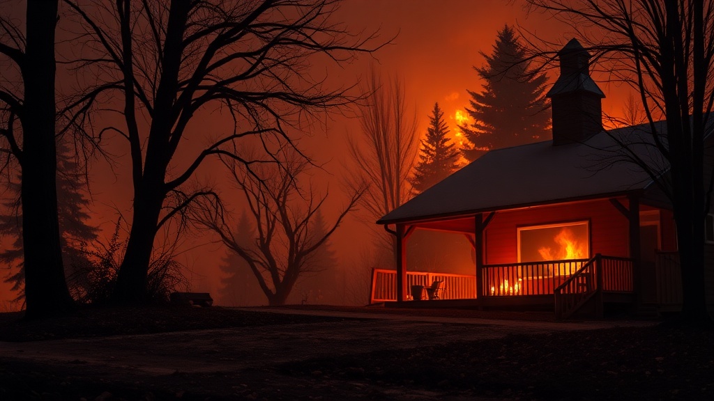
Living in the Okanagan means accepting that wildfire season arrives every summer—and preparation starts long before the smoke appears. This guide walks you through exactly what West Kelowna residents need to know about emergency alerts, evacuation planning, and household readiness specific to our unique geography.
West Kelowna sits on the west side of Okanagan Lake, surrounded by forested hillsides that make our community beautiful—but also vulnerable when dry conditions hit. The first step every household should take is registering for the West Kelowna emergency notification system. This service sends alerts directly to your phone when evacuations are ordered or when conditions change rapidly. Don't rely on social media alone; the notification system reaches you faster than any other channel.
Sign up at the City of West Kelowna website using your home address—this matters because evacuation zones are mapped by specific neighbourhoods. If you live in areas like Smith Creek, Shannon Lake, or the Rose Valley corridor, you're closer to the wildland-urban interface and need to be especially vigilant. The system works for renters and homeowners alike, so make sure everyone in your household registers their own contact information.
How do I create an evacuation plan that actually works for West Kelowna roads?
West Kelowna's road network has quirks that out-of-town emergency guides won't mention. Our primary evacuation routes run along Highway 97 and the Westside Road corridor—but during a major event, these can become congestated quickly. You need two exit strategies: one using the main highways, and one using secondary routes like Boucherie Road or Glenrosa Road depending on where you live.
Map out your specific evacuation route from your actual address, not just a general neighbourhood. If you're in the Upper Glenrosa area, your safest exit might head toward Okanagan Lake rather than inland. Drive your alternate route before wildfire season starts—note any single-lane sections, steep grades, or areas where visibility drops. During the 2023 fire season, many West Kelowna residents discovered their backup routes were blocked by others attempting the same escape path.
Pack a "go bag" that lives in your vehicle from May through September. West Kelowna's dry summers mean fire conditions can develop in hours, not days. Your bag should include copies of important documents, medications for three days, phone chargers, and something to filter smoke (N95 masks work well). Don't forget supplies for pets—our local evacuation centres at places like the West Kelowna Recreation Complex accept animals, but you need to bring their food and carriers.
What home preparation steps make the biggest difference in West Kelowna?
The West Kelowna Fire Department offers free FireSmart home assessments—and you should book one before June. These assessments identify specific risks on your property that you might overlook. Common issues in West Kelowna include cedar shake roofs (highly flammable), wooden fences that connect to structures, and pine needle accumulation in gutters.
Create a "defensible space" around your home that extends at least 10 meters in all directions. In West Kelowna, this often means removing highly flammable plants like juniper and replacing them with fire-resistant alternatives. The FireSmart BC website has plant lists specific to our region's climate. Keep your lawn watered and mowed during dry periods—even small details like moving firewood piles away from your house can make the difference between your home surviving or not.
Clean your roof and gutters twice during fire season. West Kelowna's Ponderosa pine trees drop needles constantly, and these create a perfect pathway for embers to reach your home. If you have a wood-burning fireplace or stove, ensure the chimney has a proper spark arrestor—these are required by West Kelowna bylaws but often overlooked during routine maintenance.
Where can West Kelowna residents find real-time information during an emergency?
When wildfires threaten, information moves fast—and misinformation moves faster. Bookmark these authoritative sources now so you're not scrambling later. The BC Wildfire Service provides official fire size, location, and containment updates. Their interactive map shows active fires across the province with hourly updates.
The City of West Kelowna's emergency page posts evacuation orders specific to our municipality, plus information about reception centres and road closures. Follow the City of West Kelowna's official Twitter/X account for the fastest updates during active events. Local news outlets like Castanet provide continuous coverage, but always verify evacuation orders through official city channels before leaving your home.
Know your neighbours—especially seniors or those with mobility challenges who might need help during a fast-moving evacuation. West Kelowna's community spirit shines during emergencies, and local Facebook groups often coordinate wellness checks faster than official channels can reach everyone. Just remember: unverified information on social media should never override official evacuation orders.
How can our community work together to reduce wildfire risk?
Individual preparation matters, but West Kelowna's safety depends on collective action. The FireSmart Community Recognition Program helps neighbourhoods organize group cleanup events and apply for funding to reduce shared wildfire risks. Several West Kelowna neighbourhoods—including parts of Lakeview Heights and the Westbank area—have already achieved FireSmart recognition status.
Community chipping programs run by the West Kelowna Fire Department let residents dispose of branches and yard waste that could fuel fires. Watch for these events in early spring; they're free but fill up quickly. Participating in these programs reduces fuel loads in our shared green spaces and demonstrates to insurance providers that our community takes risk seriously.
Attend West Kelowna city council meetings when emergency preparedness items appear on the agenda. The city regularly reviews wildfire mitigation budgets, and public input helps ensure resources flow toward high-risk areas. Recent investments in secondary water supply systems and strategic fuel breaks around West Kelowna's perimeter came partly from resident advocacy.
Frequently Asked Questions
What's the difference between an evacuation alert and an evacuation order in West Kelowna?
An evacuation alert means you should prepare to leave—pack your bags, move livestock if applicable, and be ready. An evacuation order means leave immediately; the danger is imminent and emergency services may not be able to assist you if you delay.
Does West Kelowna have enough water pressure to fight wildfires in hillside neighbourhoods?
West Kelowna has invested heavily in fire suppression infrastructure, including dedicated fire protection water systems in high-risk areas. However, residents should still maintain defensible space since no water system can protect every home during extreme fire behaviour.
How long should I plan to be away if evacuated from West Kelowna?
Most evacuations last 24 to 72 hours, but major fires can displace residents for weeks. Pack accordingly, and remember that even after evacuation orders lift, utilities may remain disconnected until infrastructure inspections are complete.